
Tim Vasquez and I left Norman, OK around 1pm. My friend Kathryn was visiting from Houston, so she came along as well. Our plan, based on Tim's analysis and forecast, was to head southwest to Altus, then get new data and try to refine our target. The stratocumulus got lighter as we drove, but the haze was awful the entire time, reducing visibility to only a few miles.
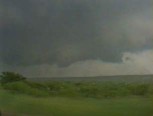
As planned, we retrieved data near Altus. At this point the area we were in had virtually clear skies (other than the infernal haze). Based on the wind fields and a mesoscale discussion that mentioned enhanced cumulus to the southwest, we decided to head south to Vernon, TX and then west. We worked our way south and west, eventually seeing some rather narrow cumulus towers that were very sheared over. One of the towers to our south was producing an anvil that was thickening rapidly, so we targeted that storm. As we headed south, the anvil spread over us and began producing mammatus. The haze was much less of a problem now that we were in the anvil's shadow.
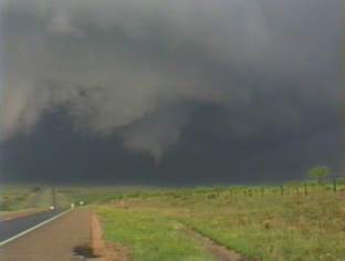
We turned west on 82 and made our way through some of the precipitation from our storm. There was somewhat heavy rain, some small hail toward the western side, and moderate lightning. We saw many cars and trucks pulled off the road to wait out the storm, and at least a couple of them were stuck in the mud. Once we broke free of the precipitation, we were able to make out the updraft base just to our south. The towers looked fairly crisp and showed some corkscrewing (not spectacular, though). The haze made the base difficult to view clearly even at this close range. As the base approached and became more visible, we noted that it was ragged looking. As it came closer still, a well defined wall cloud became evident. We parked on a ridge east of Dickens, TX, and let the wall cloud pass just to our east. It produced a small tornado at 7:34pm CDT in the field to our southeast. As soon as the dust whirl appeared on the ground, the condensation funnel stretched to meet it. I have heard reports that this tornado was on the ground for up to two minutes, but what I observed lasted less than 30 seconds.
The tornado dissipated prior to crossing the road. The wall cloud remained well defined, and for a few minutes it showed strong rotation again as it moved north of the road. Once the storm began to move to our north, we headed back east. There was the possibility of intercepting the storm again to the northeast, but impending darkness, a very poor road network, and lack of gusto on the storm's part prompted us to let it go and head home.
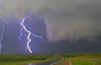
We stopped for dinner at Denny's in Altus, where the power was out in half the building - supposedly storm-related. It was probably fortunate for us that the fryers were not operative! After dinner, we made our way home and were treated to the most spectacular lightning show I have ever seen. Not only was the sky full of beautiful lace-like anvil crawlers, but the show went on, and on, and on, for several hours.
This was the first tornado I have seen while chasing, so needless to
say it was a special day for me.